Exploring Earth with NASA and India’s NISAR Satellite
Set to launch soon, NASA and India’s collaboration NISAR satellite will employ synthetic aperture radar to create detailed maps of Earth’s surface changes. Tracking phenomenon like earthquakes and deforestation, NISAR promises unprecedented insights into the planet’s dynamic systems. Discover the groundbreaking technology and its potential impacts.
The Revolutionary Technology of Synthetic Aperture Radar
The revolutionary prowess of Synthetic Aperture Radar (SAR) marks a significant departure from traditional radar systems. To appreciate this technological leap, one must first understand the basic principles of radar. Traditional radar systems operate by emitting radio waves and capturing their reflections from objects, allowing for distance measurement. While these systems effectively detected object positions, they were limited in their ability to offer detailed imagery.
Enter Synthetic Aperture Radar. Unlike its predecessors, SAR eschews the use of a physically large antenna in favor of an innovative method to synthesize a large aperture from the motion of a smaller antenna over time. This synthetic aperture allows SAR to achieve the high-resolution imaging typically reserved for systems with large, unwieldy antennas.
This capability starts with capturing data from multiple positions as the radar moves. By manipulating the received signals, engineers virtually recreate an extensive antenna array, providing the same benefits without the physical constraints. This process involves complex signal processing techniques that mathematically construct a detailed map of the terrain or object.
One of SAR’s most remarkable features is its ability to produce high-resolution images under almost any weather or lighting condition. This is particularly beneficial for Earth observation, where cloud cover and nighttime can obscure visible light images. SAR can “see” through clouds and operate day or night, making it indispensable for continuous monitoring.
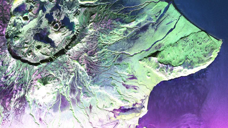
SAR technology’s advent brought about the enhancement in the understanding of Earth’s dynamic surface. The creation of interferograms is one application that showcases SAR’s mighty capability. Interferograms are images produced by combining two SAR images taken from slightly different positions or times. By analyzing the phase differences between these images, scientists can measure minute changes in terrain or structures. This allows for detecting ground movements as slight as a few millimeters, crucial for monitoring seismic activity, volcanic shifts, and glacial movements.
Another distinctive skill of SAR is polarimetry—the capacity to send and receive radio waves in various polarizations. This property is instrumental in differentiating between types of vegetation or materials on the Earth’s surface. Different surfaces reflect polarized waves uniquely, providing further layers of detailed information about Earth’s surface composition.
From a technical standpoint, SAR leverages the Doppler shift in its operations. As the radar moves, the frequency of the received signals varies due to the relative motion between the radar and the target—a principle known as the Doppler effect. This frequency shift is key to constructing the detailed radar image, as it provides information about the speed and direction of the surface elements moving toward or away from the radar. The processing of this Doppler information is vital for the synthetic aperture construction.
Moreover, achieving the desired antenna characteristics requires precise engineering. Small physical antennas used by SAR must be designed to allow for fine-tuned beam shaping and steering. The design must take into account the intended operating environment and the specific imaging requirements, ensuring the system can produce clear and accurate data.
In light of its sophisticated capabilities, SAR technology is anticipated to revolutionize the way we perceive Earth’s surface changes. The forthcoming NISAR collaboration between NASA and India is poised to further illuminate our understanding of these changes. By continuously capturing SAR data, NISAR will enable comprehensive tracking of tectonic shifts, land subsidence, and issues like deforestation, offering invaluable insights into environmental and geologic processes.
The innovation embedded in SAR technology does not just reside in its formidable technical composition, but also in the breadth of applications it opens up. These applications range from military reconnaissance to civilian and scientific uses, such as agriculture monitoring, urban planning, and disaster management. For instance, monitoring Earth’s surface post an earthquake allows authorities to assess damage and implement more effective recovery plans based on precise movement tracking.
SAR’s contribution to Earth observations becomes particularly apparent when paired with past successes in SAR applications, demonstrating how high-resolution mapping has improved our management of Earth’s resources. As the collective scientific community harnesses SAR, its future promises more groundbreaking discoveries, akin to those discussed in various scientific domains. The learnings from this technology continue to ripple through a myriad of sectors, catalyzing novel approaches to global challenges.
Thus, the journey from traditional radar to SAR marks a remarkable evolution in remote sensing technology. As the upcoming chapter will elucidate, SAR’s role in the NISAR mission will emphasize the satellite’s utility in monitoring Earth’s dynamic processes—tracking the rhythm of natural and human-induced changes with unprecedented clarity and precision. For further insights on similar technological advancements, one might explore how advancements in a seemingly different field have shaped our understanding of complex systems, as discussed in the advancement of radio telescope technology. These cross-cutting innovations collectively propel our capacity to make informed decisions about Earth’s formidable and fragile environment.
Applications of NISAR in Earth Monitoring
The NISAR satellite promises to play a pivotal role in Earth monitoring through its advanced synthetic aperture radar (SAR) capabilities. This high-resolution technology is adept at detecting even minute changes in the Earth’s surface, which paves the way for a multitude of applications, particularly in tracking natural disasters and environmental phenomena.
One of the crucial applications of NISAR is in the field of disaster management. Its ability to monitor tectonic movements positions it as a valuable tool for tracking earthquakes. NISAR can generate detailed interferometric images that reveal gradual movements in the Earth’s crust, often precursors to seismic events. By providing accurate data on fault line movements, NISAR helps in assessing earthquake risks, which is essential for disaster readiness and mitigation strategies.
Where traditional methods might lag, NISAR provides a consistent and wide-scale observational capacity. For instance, after an earthquake, SAR can help map ground deformations, assisting rescue operations by identifying areas most affected. In previous scenarios, this capability has enabled responders to effectively prioritize their efforts. With ongoing advancements in SAR technology, NISAR is expected to enhance real-time monitoring and data sharing capabilities further, making disaster response more efficient.
Additionally, NISAR’s role extends to monitoring volcanic activity. Volcanic deformation, which is a key indicator of impending eruptions, can be diligently tracked with SAR technology. Interferograms produced by SAR can detect even small-scale swelling or subsiding of volcanic areas, thereby allowing authorities to issue timely warnings.
Beyond disasters, NISAR is set to significantly impact environmental monitoring. Its ability to observe glacier movements is invaluable in studying climate change. Melting glaciers contribute to rising sea levels, posing threats to coastal communities worldwide. By tracking glacier dynamics, NISAR provides crucial data on how these changes unfold, assisting researchers in modeling future scenarios and shaping policies for climate action.
In addition, deforestation, another critical environmental concern, finds a formidable opponent in NISAR. Deforestation impacts biodiversity, carbon levels, and local climates. NISAR’s unique polarimetric capabilities enable accurate assessment of forested areas, offering visibility even through dense canopy covers. This ability allows researchers to track deforestation rates more precisely, enabling stricter enforcement of conservation laws and more precise evaluation of reforestation initiatives.
Past applications of SAR data have already underscored the benefits of such technology. For example, previous SAR missions have successfully monitored the Amazon rainforest’s deforestation, revealing hotspots of illegal logging activities. With NISAR, the expectation is to enhance these capabilities, offering higher resolution imagery that can be employed to scrutinize changes more minutely and frequently, thereby allowing immediate action against wrongful land use practices.
SAR’s contribution to oceanography through NISAR is another promising avenue. By detecting anomalies in sea ice movements, SAR data will support the understanding of polar climates and marine ecosystems. This is critical given the ecological impacts of ice melting and habitat shifts. Moreover, tracking surface water dynamics aids in managing water resources, a vital aspect in regions prone to droughts.
Expectantly, NISAR will also empower advancements in agriculture, a critical sector affected by climate variability. By observing seasonal changes in soil moisture and crop cultivation patterns, NISAR offers data indispensable for modern precision farming techniques. This ensures optimal resource allocation and robust food security measures.
For urban planning, NISAR’s granular observation abilities assist in monitoring land subsidence caused by excessive groundwater extraction. Such subsidence, often imperceptible over short periods, could lead to infrastructure instability. By providing early warning signs, NISAR plays a part in urban risk management and sustainable development.
Moreover, NISAR’s contributions to areas like hydrology—through snow cover monitoring—are crucial for understanding water cycles. These insights contribute to models predicting snow melt events, crucial predictors of river water levels and potential flooding scenarios.
Amidst the various potential contributions of NISAR, it becomes apparent that the satellite represents a significant leap in SAR application. The integration of its data with artificial intelligence and machine learning models is expected to further enhance predictive analytics, providing stakeholders with actionable insights.
While past SAR missions have laid the groundwork, the deployment of NISAR heralds a new era of Earth monitoring, powered by unprecedented data detail and frequency. It is this potential for transformative insight that underscores the importance of such innovative technology in safeguarding our planet’s future.
In anticipation of its deployment, researchers and policymakers are preparing to harness the wealth of data expected from NISAR. Collaborations across the globe are being fortified to ensure the data’s effective application in disaster management, environmental conservation, and policy frameworks, making the NISAR mission a cornerstone in Earth observation efforts.
As we continue to evolve technological capabilities, the integration of detailed SAR insights offered by NISAR will likely catalyze new approaches in addressing globally significant challenges, cementing its place in the expanding portfolio of space-based Earth monitoring technologies. For further reading on the technological intricacies and applications, you can explore the wealth of information available in resources like this.
The Collaborative Effort Behind NISAR
The partnership between NASA and ISRO on the NISAR satellite underscores a deep commitment to international collaboration in the realm of space exploration. This collaboration germinated from a shared vision of enhancing our understanding of Earth’s processes using advanced radar technology. Both organizations recognized the utility of using synthetic aperture radar (SAR) for Earth observation. Their common goals fostered a groundbreaking alliance that culminated in the creation of the NISAR mission.
This collaboration is not the first instance of cooperation between the United States and India in space exploration. Both countries have a rich history of partnerships, dating back to the early days of satellite communications. Over the years, these collaborations have expanded into more complex projects, reflecting a growing trust and mutual respect. The NISAR mission represents the pinnacle of these efforts, combining NASA’s expertise in satellite engineering and ISRO’s prowess in launching low-cost, effective space missions.
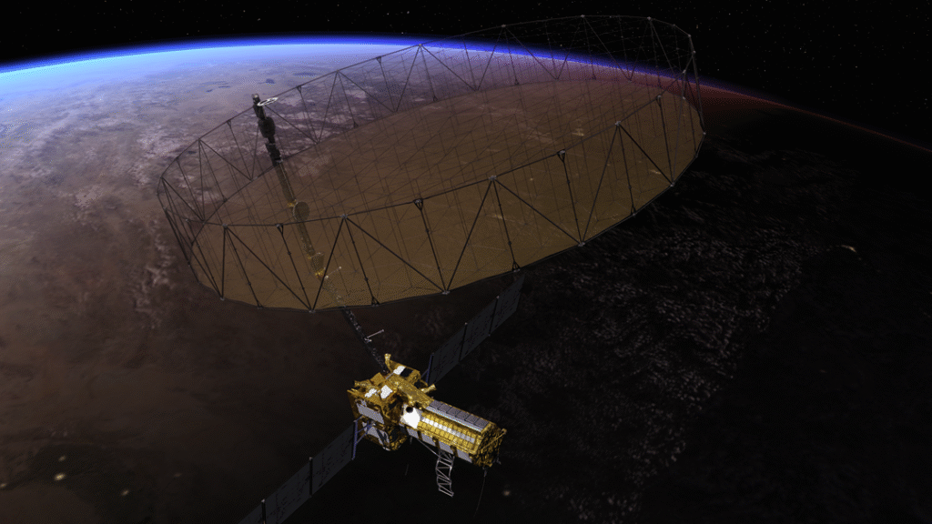
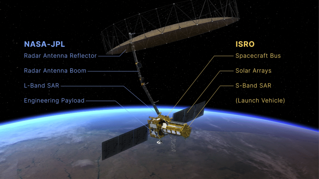
The NISAR satellite, short for NASA-ISRO Synthetic Aperture Radar, aims to provide data critical to Earth monitoring. It is designed to give detailed insights into Earth’s surface dynamics, from minute changes in terrain to tectonic plate movements. Such observations are essential in understanding natural disasters, climate change, and environmental conservation. In aligning their resources and expertise, NASA and ISRO seek to break new ground in Earth sciences, employing cutting-edge radar technology.
In the collaborative process of developing NISAR, clear roles were delineated. NASA took charge of providing the L-band SAR, a sophisticated radar system known for its ability to penetrate dense vegetation and soil. This technology enables scientists to study a variety of terrestrial phenomena, including estimating biomass and deforestation. The L-band SAR is also adept at tracking subtle shifts in Earth’s surface, which can be crucial in predicting potential natural disasters.
On the other hand, ISRO contributed the S-band SAR, a complementary radar system tailored for measuring agricultural patterns and providing important information about water inundation. ISRO also played a significant role in designing the spacecraft’s bus, the system responsible for the satellite’s power, thermal, and telecommunications needs. With these contributions, ISRO ensures that the satellite remains functional across its intended lifespan, maintaining robust data transmission back to Earth.
The NISAR project also witnesses India’s application of its PSLV (Polar Satellite Launch Vehicle) for the deployment of the satellite. Known for its reliability and precision, the PSLV has become ISRO’s cornerstone for launching various satellites, making it the fitting choice for such a critical mission.
Such scientific collaboration is a testament to the two space agencies’ commitment to transcending national boundaries and merging technological expertise for the greater good. By working together, NASA and ISRO have crafted a mission that serves the international community, providing invaluable data to scientists and policymakers worldwide. This partnership exemplifies how shared objectives can spur innovation and yield mutually beneficial outcomes.
The significance of NISAR transcends scientific curiosity. This mission signals a vital step towards global monitoring and preserving our planet. It is equipped to observe how human actions and natural phenomena alter landscapes and interact with various ecosystems. Scientists expect NISAR to contribute significantly to understanding the lifespan of glaciers, the extent of agricultural land use, and the impacts of coastal erosion.
The satellite aims to offer a more comprehensive view than previous missions. It will complement the work conducted by other Earth-based and spaceborne observatories. By collecting data on Earth’s surface changes over time, NISAR will aid in addressing urgent global challenges, from food security to disaster response.
Reflecting on historical successes, synthetic aperture radar technology has been instrumental in various fields. It has facilitated analyses that inform on urban development, emergency response, and resource management. The data from SAR-equipped satellites have proved invaluable, especially in regions that experience high natural disaster risks. SAR sensors help monitor earthquake-prone tectonic activity, offering a window into the precursors of volcanic eruptions and landslides as well.
In this context, NISAR’s offering extends beyond the technical. It enhances our collective ability to anticipate shifts and disruptions, fostering resilience against unforeseen natural events. As Earth’s future becomes inextricably linked with climate change, missions like NISAR serve as vital tools for adaptation and sustainable decision-making.
Moreover, NISAR is expected to enhance many other fields of research. It contributes to a deeper understanding of cryosphere changes, identifying new threats to water resources globally. NISAR’s detailed data promise to facilitate environmental protection, linking researchers across different fields, from geologists to meteorologists.
While this mission’s primary focus lies in Earth observation, it also sets a precedent for future collaborative endeavors. The success of NISAR will encourage further partnerships and foster new avenues in scientific inquiry and technological development.
In wrapping the fabric of diverse landscapes into a collection of pixels and resolving them into actionable data, NISAR stands as a blueprint for what countries can achieve when united by a common cause. As a result, it supports global readiness in facing environmental challenges and drives us toward a more informed, adaptive world.
The landmark collaboration between NASA and ISRO extends beyond shared resources and mutual benefits. It also exemplifies a trust in shared scientific endeavors. As countries continue to navigate partnerships in space exploration, the NISAR mission remains a shining example of what collaboration can achieve. It promises not only to illuminate Earth’s mysteries but also to chart a path for future international missions in space exploration.
For those keen on delving deeper into the intricate web of collaborations that propel space research forward, exploring resources on international cooperation in the space sector can offer rich insights. For example, more about the spacecraft initiatives that model international cooperation can be found on ScienceTeen, a site exploring various aspects of space science and technology.
Final words
NISAR represents a monumental step in Earth observation, providing detailed data on surface changes. It will deepen our understanding of natural processes and aid in disaster monitoring and environmental conservation efforts, contributing vastly to scientific research and practical applications.